Dubai / WAM
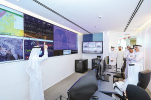
Saeed Mohammed Al Tayer, MD & CEO of Dubai Electricity and Water Authority (Dewa), inaugurated Dewa’s Ground Station at the Research and Development (R&D) Centre in the
Mohammed bin Rashid Al Maktoum Solar Park. The independent ground station, which is part of Dewa’s Space-D programme, is capable of tracking and communicating with Dewas satellites at their low Earth orbit of 400-700 kilometres.
Waleed Bin Salman, Executive Vice President of Business Development and Excellence at Dewa; Dr Ali Rashid Al Aleeli, Vice President of R&D, Business Development and Excellence at Dewa, attended the inauguration along with the R&D Centre’s staff.
Al Tayer praised the efforts of the R&D Centre researchers in developing and building the ground station. He commended their success in innovating state-of-the-art technologies and developing solutions using Internet of Things (IoT) technologies for the satellites. Al Tayer highlighted the role of the researchers in developing specialised systems for electricity and water transmission, generation and distribution as well as enhancing the management of the power network and the water transmission and
distribution networks.
“Through the Space-D programme, launched by His Highness Sheikh Mohammed bin Rashid Al Maktoum, Vice President and Prime Minister of the UAE and Ruler of Dubai in January 2021, we aim to make nano satellites a complementing technology to the ground IoT communications network. This will support the digitisation of the power and water networks, enhance the planning, operations, and preventative maintenance for the generation, distribution, and transmission divisions as well as the smart grids and the electric vehicle charging stations. This will also cut costs, improve investment of Dewa’s assets, share knowledge and experience, as well as train Dewa’s Emirati staff. During Q1 of 2023, we plan to launch a 6U nanosatellite with customised high-resolution image sensing technology specifically designed for Dewa’s use cases,†added Al Tayer.
The use cases of the ground station will include monitoring of water salinity, water temperature, water quality, and fog detection and forecasting at the Jebel Ali Power Plant and Water Desalination Complex.
Dewa’s Space-D programme has contributed to enhancing Dewa’s resilience and agility in monitoring and managing electricity and water networks, in addition to reducing costs, improving investment and management of its assets, and proactively supporting its networks. The programme aims to build the capacity of Dewa’s employees and prepare Emiratis who are specialised in using space technologies in electricity and water networks.
The programme takes advantage of Fourth Industrial Revolution technologies to exchange information with the help of satellite communications and earth observation technologies. It also enhances the performance and efficiency of the photovoltaic solar panels at the Mohammed bin Rashid Al Maktoum Solar Park, the largest single-site solar park in the world.
Dewa is the first utility in the world to use nanosatellites to improve operations, maintenance and planning of electricity and water networks. Launching the 3U nanosatellite has enabled the R&D team to gain the latest knowledge and experience to understand the effectiveness and value of the IoT nanosatellite constellation in supporting utilities such as Dewa to improve the management of their power grid and water transmission and distribution networks.
Dewa is taking advantage of the Fourth Industrial Revolution technologies such as IoT, data analytics, AI and blockchain to provide value from the data received from our IoT terminals via the satellite constellation network. Dewa uses a digital IoT platform hosted by its own data centre that is managed by the Data Hub Integrated Solutions (Moro), the backbone of Digital Dewa.
The R&D Centre designed the satellite LoRa IoT terminals to be capable of communicating using Infra-X LoRa terrestrial as well as LoRa Space-D satellite communication networks. It is a type of new wireless protocol designed for long-range, low-power communications, to expand the coverage of the existing terrestrial communication network. Once the satellites are operational, remote asset data can be collected at a much lower cost and in a much faster time compared to expanding the coverage of the terrestrial network, especially in areas with rough terrain, such as mountains, forests or deserts. The accuracy of weather forecasting can be improved as well as climate factors including irradiance, dust and cloud movement.
 The Gulf Time Newspaper One of the finest business newspapers in the UAE brought to you by our professional writers and editors.
